operation
DENALI 2009
|
|
Overview |
| Team | |
| TIMELINE | |
| Logistics | |
| Sponsors | |
| News Coverage | |
| About Denali | |
| Links | |
| Donations |


Denali Expedition, 20,320 feet / 6,194 meters
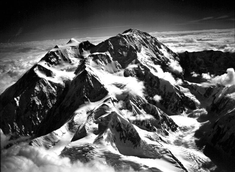
View of The West Buttress from 22,000 feet.
©Bradford Washburn, courtesy Panopticon Gallery, Boston, MA
ROUTE: WEST BUTTRESS, ALASKA GRADE II, 13,000 FEET ELEVATION GAIN, 41 MILES, 21 DAYS
(Excerpts from Alaska Mountain School's West Buttress Climb Description)
THE MOUNTAIN
Denali, formerly Mt. McKinley, is America’s tallest mountain and un-surpassed in challenge or scenic beauty. At 20,320 feet, it rises out of a sea of glaciers and other peaks that compose the Alaska Range. From our start at base camp, we climb 13,000 vertical feet to the summit –the greatest elevation gain of any mountain in the world. 150 miles north of the port city of Anchorage, Denali is the largest massif in Alaska’s Denali National Park and Preserve.
A guidebook description of the West Buttress route can be found in, “Denali’s West Buttress: A Climber’s Guide” by Colby Coombs, The Mountaineer’s Books.
HISTORY
The early pioneers in Denali's climbing history were explorers and gold miners who unraveled intricate and formidable approaches to find a northern route to the summit. In 1910, a group of Sourdough miners struck out from Fairbanks to climb the slightly lower North Peak, 19,470 feet. In 1913, Archdeacon Stuck's team climbed the same route via Kirsten’s Ridge, making the first ascent of the higher South Peak, 20,320 feet. Flying from the south and landing on the Kahiltna Glacier The West Buttress of Denali was pioneered by Bradford Washburn's team in 1951 and is the most popular route to the summit.
GRADE/DIFFICULTY
Given a Grade II, the West Buttress shares with the Muldrow route the status of having the lowest grade on Denali. This implies it is the “easiest and safest route” to the summit. “You camp up Denali, not climb it.” Relative to other climbs on Denali, it is easier and the terrain is safer. However, be warned, it is never easy on Denali! Unique to Denali’s rating system is an implied severity grade that makes any route a serious undertaking. High altitude, extreme weather, and active glaciation combine to make Denali one of the most difficult and severe mountains in the world to climb. AMS’ attitude takes Denali very seriously and does not under-estimate the severity of conditions or the effects of high altitude. To reach the summit of Denali is a worthy achievement that does not come easily and must be sought after with the highest degree of attention to detail and expedition climbing strategy.
PRIOR EXPERIENCE
Denali is a tremendous challenge for people with the experience and attitude to enjoy the rigors of expedition life. As an advanced climb, Denali requires a significant amount of prior climbing experience and training beforehand. For the best chance of success, applicants should be in excellent physical condition and have climbed mountaineering routes that require roped glacier travel, winter snow camping, and the use of an ice axe and crampons. Prior winter camping and travel experience for extended periods of time is essential training. Dealing with the cold on Denali is a day-to-day challenge. The figure eight knot series, rope coiling, and belaying with a munter hitch should be familiar. The ability to arrest a fall on a steep snow slope with a pack is paramount to your safety and the safety of your rope team. Above 16,000 feet, expect to crampon with a 60-plus pound pack on slopes up to 30-35°. Some sections of the route require you to bend down and clip through running belays. The mountain is too severe to be learning these skills for the first time. Smaller peaks in the Alaska Range, winter climbs of Mt. Washington, Colorado 14’ers, Mt. Rainier, the
Teton’s, Mount Blanc are suitable training grounds for Denali. A non-technical, high altitude climb is a great way to train for the altitude. Our best prepared expedition members have taken a mountaineering course and trained for a year before joining an expedition.
WEATHER
It is often said that the greatest challenge of Denali is not the climbing, but the weather. While most of the world’s highest mountains are near the equator, Denali is closer to the North Pole. Its location in the southern Alaskan mainland is 200 miles south of the Artic Circle at 63°°. This is 35°° further north than Everest, the same latitude as northern Hudson Bay and central Scandinavia. Denali’s climate around its summit is one of the most severe year-round averages of any spot on earth. The weather dictates our every move and is fickle and un-predictable. It will force us to be flexible and patient and sometimes spontaneous. It is the one thing we cannot change, but we will work with.
WHEN TO CLIMB
The most common question asked by climbers is “which is the best month to climb?” There is no right answer as every year is different than the previous year as far as weather and conditions. It is generally agreed that the popular climbing season on Denali begins late April and lasts through most of July, shrinking the acceptable window down to 90 days. In March and April, cold temperatures and strong winds at higher elevations make conditions too severe. The month of May shows less precipitation on average than June or July, but it is colder and requires more aggressive cold injury prevention. Statistically, there are more people on the mountain in June and therefore more people summit. Once you start getting into mid to late July, the snow conditions on the lower half of the mountain can deteriorated so bad that crevasse hazard becomes extreme and landing conditions impossible
LEADERSHIP AND TEAM WORK
Successful expeditions are properly equipped, have the necessary skills, but most importantly they learn to become a strong team. Good leadership reflects the art of effective team building. From base camp to advanced base camp (ABC) your guides teach classes, hold discussions, and initiate you into the world of expedition life. Above ABC and all the way to the summit your expedition will show signs of strength: tight camps, efficient travel techniques, and positive team playing. We expect you to stay organized, participate all the way, and have fun while supporting the goals of the expedition. Of primary importance is taking responsibility for monitoring yourself; you know best how you feel, how you sleep, how you recover each day. As a team, we are able to help if someone is having a bad day, but ultimately every member must be a regular contributor for the expedition to be successful. Not participating, or failing to meet the day-to-day demands may lead to your departure from the expedition. We expect
you to maintain good expedition behavior (EB): be supportive, solution-oriented, hard working, patient, take initiative and in return you will be rewarded with the climb of a lifetime.
THE CLIMB
We climb the West Buttress in traditional expedition style, relaying loads, establishing camps, and climbing slowly enough for proper
acclimatization. The first nine miles of the route is up the Kahiltna Glacier to 11,000 feet. We typically place three camps on this section of the route. Above 11,000 feet, the terrain steepen’s and we switch to crampons. ABC is 14,200 feet and located in a large basin relatively sheltered from high winds. We often arrive at 14,200 feet on the 9th day. The views of Mt. Hunter and Mt. Foraker from here are amazing. After 4-5 days acclimatizing, resting, and making a carry to 16,200 feet, we depart for the upper mountain. Between 15,500 feet and 16,200 feet are 40-45 ° slopes so we climb clipped to a fixed rope to safeguard our movements. We often place a camp at the top of the fixed ropes at 16,200 feet to break up the climb or wait for
better weather. The stretch to high camp at 17,200 feet is the most scenic part of the route and climbs a narrow ridge to 17,200 feet. When rested and in suitable weather, we will go for the summit. Summit day usually takes 10-14 hours. We cannot guarantee it, but we give it our best shot. Be prepared to wait. After summitting, it usually takes 2 days from high camp to return to base camp.
AMS’ approach to Denali falls in line with our mission as a school of mountaineering. Denali’s summit is a means, not an end, and we will be pushing every day to increase our performance. The mountain provides an excellent stage to practice good mountaineering. We expect all members to share a goal of becoming better climbers on our expeditions.
ITINERARY
Day 1 Orientation, gear check, NPS registration, pack lunches, fly to Base Camp, distance: 60 miles, elevation gain: 6850’.
Day 2 Base Camp: organize, acclimate, review glacier travel and crevasse rescue.
Day 3 Single to Ski Hill, Camp 1, 7,800’, distance: 5.5 miles, elevation gain: 600’.
Day 4 Carry to Kahiltna Pass, 9,700’, distance: 5 miles, elevation gain: 1900’.
Day 5 Move to Kahiltna Pass, Camp 2, 9,700’, distance: 5 miles, elevation gain: 1900’.
Day 6 Single to 11,000’, Camp 3, distance: 1.5 miles, elevation gain: 1300’.
Day 7 Rest day
Day 8 Carry to 13,500’ around Windy Corner, distance: 1.75 miles, elevation gain: 2500’.
Day 9 Move to 14,200’, Camp IV, distance: 2.75 miles, elevation gain: 3200’.
Day 10 Back carry 13,500’ cache, distance: 1 mile, elevation gain: 700’.
Day 11 Carry to 16,200’ , distance: 1 mile, elevation gain: 2000’.
Day 12 Rest at 14,200’.
Day 13 Move to 16,200 feet or 17,200’, Camp V, distance: 1.75 miles, elevation gain: 3000’.
Day 14 Rest day or move to 17,200 feet, C amp VI, distance: 1.75 miles, elevation gain: 3000’.
Day 15, 16, 17, 18 Summit days, distance: 4 miles, elevation gain: 3120’.
Day 19 Return to 14,200 feet or 11,000’, distance: 2.25 miles.
Day 20 Return to Base Camp, 7,200’, distance: 11.25 miles.
Day 21 Fly back to Talkeetna.